
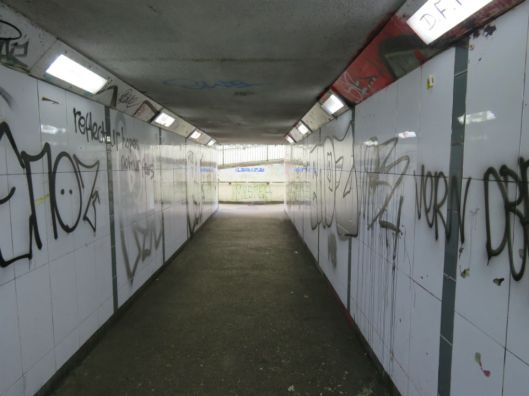
Previously [1] … I spent so much time exploring Norwich’s medieval St Augustine’s that I never made it to the marketplace. Unless you fancy playing chicken on the inner ring road there is only one way to continue directly to the city centre and that is to walk beneath the flyover as it struggles to clear poor old Magdalen Street. So I escape to the former industrial area via St Crispin’s underpass.
On the other side everything is sweetness and light. We are still in Norwich-over-the-Water but at least we are away from the lowering presence of the Anglia Square development, modern buildings are in scale, the old street pattern has largely survived and there is a better class of graffiti.
The more sympathetic renovation of the former industrial quarter may be part of what Pevsner and Wilson [2] have called the “welcome softening of approach since the late 1980s“. Around the corner on St Georges Street is a pair of houses that were renovated rather than demolished – the one on the right bearing a plaque dating it to “1670 renewed in 1986“. The larger building used to be the King’s Head pub and gained two dormers/lucams in the restoration [3]. The postmodern office block forming a backcloth is Cavell House.

C17 house with Cavell House in the background. Note its different window styles
As a postmodern building Cavell House kicks against the uniformity of modernism by including a variety of references, some of them playful. For instance, the horizontal run of windows on the upper floor resembles the long ‘throughlight’ windows once common in the heart of the Norwich weaving industry.
Nos 3-5 Calvert Street 1936, destroyed by enemy firebombs in 1942. Note the weaver’s window in the upper floor. Courtesy http://www.georgeplunkett.co.uk
The brick arches above the lower windows in Cavell House are borrowed from the next building along St Georges Street, Sherwyn House.
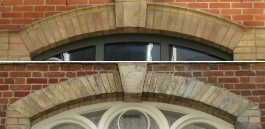
Window arches on Cavell House (above) and Sherwyn House (below)
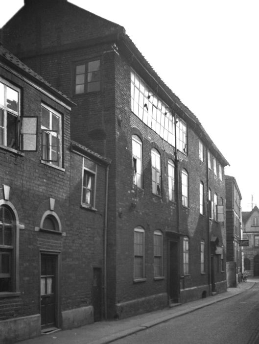
The style of Sherwyn House is reminiscent of Edward Boardman’s 1876 shoe factory for Haldinstein’s in Queen Street and his design for Howlett & White’s ‘Norvic’ shoe factory a few hundred metres away in Colegate [4]. However, the 1885 map of Norwich clearly shows a ‘brush manufactory’ on this site, not a shoe factory [5] and Kelly’s Directory for 1883 confirms the owner to have been Henry Mullett.

St Georges St, derelict brush factory 1983 built 1867. Courtesy http://www.georgeplunkett.co.uk
By 1983 the brush factory was derelict and became part of the 1992 Calvergate development by Feilden and Mawson [6].

Sherwyn House, St George’s Street, now retirement apartments
Just beyond Sherwyn House, a U-turn up Cross Lane then a right into Golden Dog Lane brought me to a building I had previously seen from the other side of the flyover.
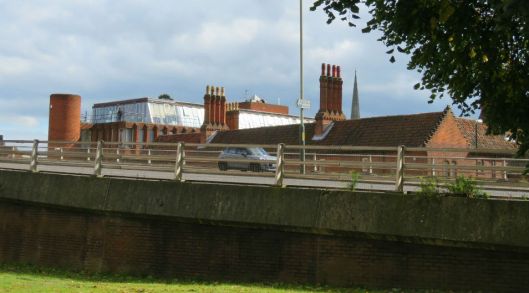
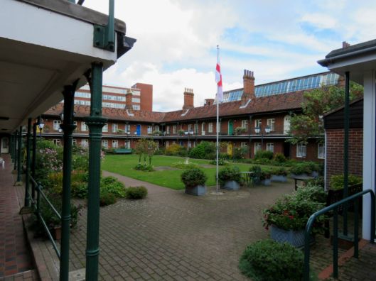
The defiant Tudor-style chimneys and crow-step gable belong to Doughty’s Hospital, an alms house founded in 1687 by William Doughty for 24 poor men and eight poor women. By the mid C19 only a sparse outline of the original building remained and it was rebuilt in 1869 [7]. Now it provides 57 sheltered flats for the elderly.
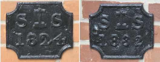
On a wall are two parish plates. In the Georgian era, in the absence of detailed maps, such plates were the way of defining the boundaries of the parish and its social and legal responsibilities [8]. The letters S stand for C14/15 Saint Saviour’s Magdalen Street – the church with the truncated tower now literally overshadowed by the flyover. The insignia between these letters represents the stone cross that stood at the former junction of Magdalen and St Botolph’s Streets [9].
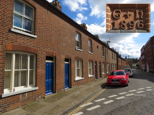
Retracing my steps into Cross Lane I looked down Calvert Street towards Colegate and the castle beyond. On the left side are two fine rows of red brick Victorian houses: one recording ‘GH 1896′ in Guntons’ tiles, the other with a stone inscribed ‘Thompson’s Buildings 1859’. A resident told me these were once council houses, sold under the Right-to-Buy scheme.
Across the cobbled street is a grander prospect – a reminder of the area’s former prosperity.
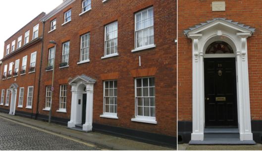
20 and 22 Calvert Street. Above the doorway to No20 a plaque reads ‘Snaylgate House 1802’
The street was named for a former Sheriff of Norwich John Calvert (1741) who owned a house here. Before Calvert the street was Snaylgate and before that Snackegate [10]. The linguist Peter Trudgill says that ‘snek’ is an old Dutch dialect word for snail [11], underlining the historical connection between this weaving city and the immigrants from the Low Countries. ‘Gate’ comes from the old Danish word for street and is encountered in towns, like York and Norwich, once part of the Danelaw. This link is celebrated in a ‘Viking Norwich’ wall plaque stating that the street runs along an Anglo-Scandinavian defensive bank and ditch.
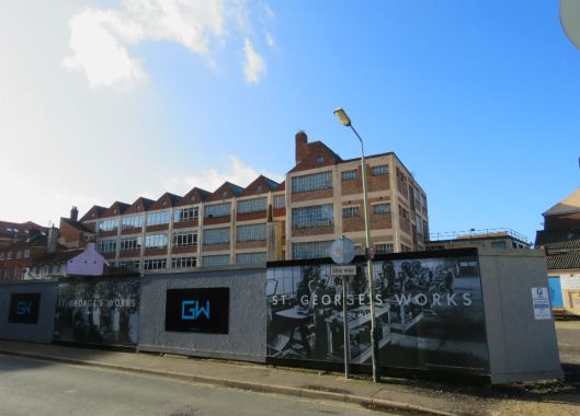
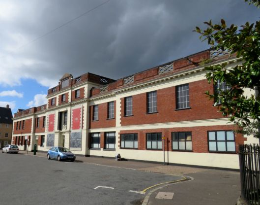
Retracing my steps down Cross Lane I enter Muspole Street via Alms Lane. It is from here that I see the St George’s Works building site with Howlett and White’s Norvic-Kiltie shoe factory (1926) in the background. This was an adjunct to their huge Norvic shoe factory on St Georges Street and whose roof can just be glimpsed to the left. In 1909 the firm employed 1200 workers [12].
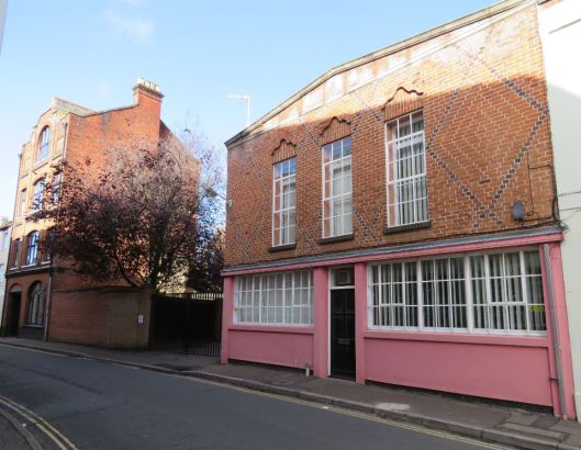
To the right, there is an interesting parade of resurrected industrial buildings along Muspole Street; I am particularly taken with a building faced with mathematical tiles. The Crittall windows on the jettied first floor, with eyebrows made from ridge and pantiles, suggest the house was renovated between the wars.
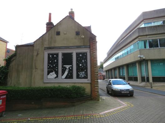
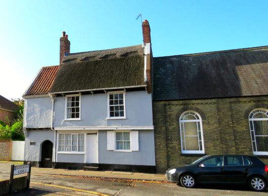
Walking straight over Duke Street I enter one of the city’s 15 open spaces – St Mary’s Plain. Where other cities have squares Norwich has plains [13]. ‘Plein’ is another borrowing from the C16 Dutch and Flemish Protestant refugees who, fleeing Spanish Catholic persecution, settled here and reinvigorated our weaving trade. Next to Zoar Strict and Particular Baptist Chapel, is the former home of Thomas Pykerell, cloth merchant, sheriff and three times Mayor of Norwich in the C15. Pykerell’s House is one of only a handful of thatched buildings in the city. It was gutted by incendiary bombs in the 1940s and we are fortunate to have it in its restored state.
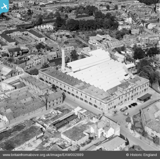
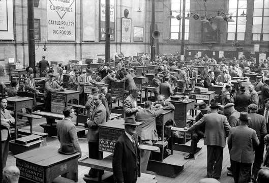
The square is dominated by another former shoe factory, now being redeveloped as part of St Mary’s Works. The name of Sexton Son and Everard Ltd, which is over-painted, sits on top of the building – the blacked-out lettering an unwitting reminder of the damage inflicted in the Blitz. The business that started in 1876 folded in 1976.
This aerial photo of the factory in 1946 gives an idea of the extent to which Norwich-over-the-Water was dominated by industry.
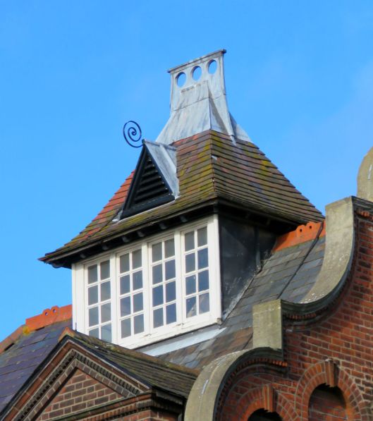
Now for Duke Street, widened in 1972 to become the main feeder for the inner ring road. Duke St is named for the Duke of Norfolk’s C16 palace that once stood roughly on the site of present-day St Andrews Street car park [14]. I have previously mentioned the 1888 Norwich Board School on Duke St that is now part of the Norwich University of the Arts [4] but I can’t pass it without showing one of my favourite architectural folderols: this roof lantern with its lead cockade.
I exit Norwich-over-the-Water via the Duke Street bridge. The original Duke’s Palace Bridge of 1822, made entirely out of cast iron, was moved as part of the 1972 road widening scheme and re-erected over the entrance to the Castle Mall car park [2].

A riverside gangway to the left of the present bridge provides a vantage point over the river, across to the site of Howlett and White’s factory on St George’s Plain and one of the last remaining chimney stacks in an area that once bristled with them (there is another behind the Brush Factory, now Sherwyn House (above).
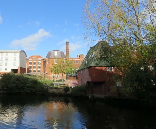
To the right of the bridge the mostly derelict complex, between river and Charing Cross, was once devoted to the generation of electricity.

In 1892 Boardman and Son designed the conversion of the old Duke’s Palace Ironworks for the Norwich Electric Light Company who supplied the city’s street lamps. But by the 1920s this was superseded by the power station at Thorpe and the Duke Street site was converted to offices [4].
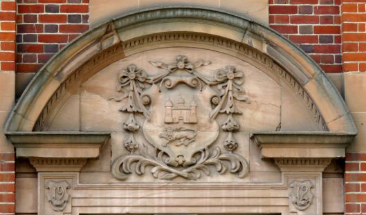
The city coat of arms on the former offices of the Norwich Electric Light Company, Duke Street [4].
Left into St Andrews Street then right into one of the very few post-medieval streets in the city: Exchange Street. Originally called Museum Street then Post Office Street it was renamed once more after the opening of the Corn Exchange (1828). In 1832 Exchange Street finally connected through to St Andrews Street, allowing traffic to flow over the recently opened Duke Street Bridge then to points north via St Augustine’s Gate [2, 15].
In 1861 the original corn exchange was replaced by a larger one that functioned well into the C20.
The ‘new’ Corn Exchange in 1960. © Copyright Historic England Archive ref: AA98/12867
But a century later (1963) this larger corn exchange (seen below) was in turn demolished to make way for the extension to Jarrolds Department Store at the corner of Exchange and Bedford Streets.
![Exchange St Corn Exchange west side [2513] 1938-06-26.jpg](https://colonelunthanksnorwich.com/wp-content/uploads/2017/10/exchange-st-corn-exchange-west-side-2513-1938-06-26.jpg?w=529)
The 1861 Corn Exchange seen in 1938 from the market end. http://www.georgeplunkett.co.uk
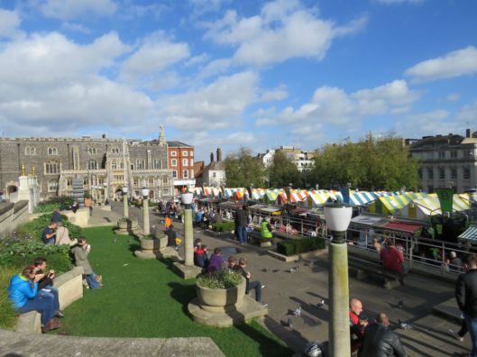
At last, the marketplace. The Anglo-Saxon market was based in Tombland but the entire axis of the city changed when the Normans built the castle in the late C11 and installed a market in its present position, outside the motte in the Mancroft district [16]. Over recent years there had been too many unoccupied stalls in the 900+ year–old market but there seems to be a revival of its fortunes due the city council’s introduction of a ‘Global Market’ – pop-ups selling street food from around the world. Hybrid vigour comes to the rescue, as it has done throughout the long history of this city [17].
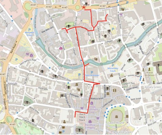
©OpenStreetMapscontributors
©2017 Reggie Unthank
Thanks to Frances Holmes, Martin Shaw and John Fuller for their assistance. I am also grateful to the www.georgeplunkett.co.uk website run by Jonathan Plunkett.
References
- https://colonelunthanksnorwich.com/2017/10/15/gildencroft-and-psychogeography/
- Nikolaus Pevsner and Bill Wilson (2002). The Buildings of England. Norfolk I, Norwich and North-East. Pub: Yale University Press.
- http://www.georgeplunkett.co.uk/Norwich/stc.htm#Stgeo
- https://colonelunthanksnorwich.com/2016/07/28/norwichs-pre-loved-buildings/
- http://www.norwich-yards.co.uk/norwich_map_1885/norwich_map_15600.asp?ID=2210
- http://www.mbp-uk.com/projects/fscalvergate.html
- https://historicengland.org.uk/listing/the-list/list-entry/1187193
- David A Berwick (2007). Beating the Bounds in Georgian Norwich. Pub: davidaberwick@gmail.com.
- http://www.heritage.norfolk.gov.uk/record-details?MNF597-St-Saviour%27s-Church-Magdalen-Street-Norwich&Index=593&RecordCount=56542&SessionID=6df6bab1-16b0-4b3f-9ba9-746ca0e3740d
- www.georgeplunkett.co.uk Calvert St 20 to 22 [2676] 1938-08-03
- http://www.edp24.co.uk/news/how-snailgate-became-calvert-street-1-4805457
- Frances and Michael Holmes (2013). The Story of the Norwich Boot and Shoe Trade. Pub: Norwich Heritage Projects (www.norwich-heritage.co.uk).
- Richard Lane (1999). The Plains of Norwich. Pub: The Larks Press.
- http://www.eveningnews24.co.uk/news/politics/dig-could-reveal-secrets-of-norwich-s-lost-16th-century-palace-1-4015633
- http://www.racns.co.uk/sculptures.asp?action=getsurvey&id=915
- https://en.wikipedia.org/wiki/Norwich_Market
- http://www.edp24.co.uk/news/street-food-and-pop-up-stalls-give-norwich-market-remarkable-boost-1-5166418

Thanks, really enjoyed that!
LikeLike
Praise indeed from a Norfolk girl – thanks Lynne
LikeLike
I love this one especially – thank you!
LikeLiked by 1 person
Thanks Heather. Some day soon I’ll walk Magdalen Street
LikeLike
I appreciate the comment Heather.
LikeLike
Fantastic as always, Reggie.
LikeLiked by 1 person
Thanks for the kind words, Katherine
LikeLike
I really enjoyed this tour and appreciate all your research, Reggie.
LikeLike
The research is the fun part, taking me to parts of the city beyond my usual haunts. Thank you for following Clare
LikeLiked by 1 person
My pleasure!
LikeLike
Fascinating! Why was industry so attracted to this area- were there any rail links? Alan
LikeLike
Hi Alan, The Norwich City Station opened in 1882; it was only a few hundred yards from this industrial area and connected with the Midlands. However, there had been a longer connection to the outside world via the River Wensum, which accounts for the concentration of industry along its banks.
LikeLike
Reggie,
Very interesting. Pity I did not have a map
of Norwich in Marbella,
Look forward to the next one,
Maarten
LikeLike
Your A-Z of Norwich is in the post, Maarten
LikeLike
I see the Council will permit the demolition of the old Electricity Offices for new development – no mention of the fact that long before ground source heatpumps became fashionable they were heated by a heatpump using the river. Something else to research one day! As always an excellent review of a great area of the City
Don Watson
LikeLike
Fascinated to learn that heat was extracted via the river, Don. The area does need a sympathetic makeover but I do hope that the Boardman building is retained; enough time has passed for us to see that his buildings throughout the city are all of a piece, making a distinctive contribution to its fabric.
LikeLike
Wonderful. And I particularly love that you’ve featured the former King’s Head pub which I rented for a couple of years. A great place to live.
LikeLiked by 1 person
Thanks Jack. The Old King’s Head looks like a great place to have lived – historic and so close to town.
LikeLike
Pingback: Nairn on Norwich | COLONEL UNTHANK'S NORWICH
Pingback: Twentieth Century Norwich Buildings | COLONEL UNTHANK'S NORWICH