
Over the years Norwich’s largest public green space has been known as Chapel-in-the-Fields, Chapel Fields, Chapple/Chapply/Chaply/Chapley Field, and now Chapelfield Gardens [1]; my daughters call it Chappy. We saw the area last when genteel Georgians promenaded around its triangular walk [2] but this only occupied a thin slice of time for the name goes back a further half millennium to when John le Brun founded the Chapel of the Blessed Virgin Mary in the Fields (1250). This evolved into the College of St Mary in the Fields, part of which was to be incorporated into the Georgian Assembly House (1745-6).
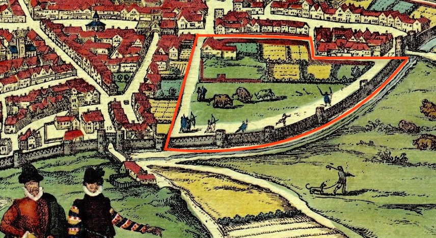
Braun and Hogenberg’s prospect of 1581 is based on Cuningham’s map of 1558 so provides a glimpse of Chapel Field around the time of Henry VIII’s Dissolution of the Monasteries. In 1569 the ownership of Chapel Field was transferred to the city. The map shows this sector dominated by two areas of open ground: the land behind Chapel Field House and a triangular meadow grazed by cows and occupied by figures with bows and arrows. This was at a time when it was still compulsory for men between the ages of 15 and 60 to prepare for war and we see them practicing archery under the walls. But warfare was changing and by the latter part of the century the field became the mustering ground for the city’s trained artillerymen.
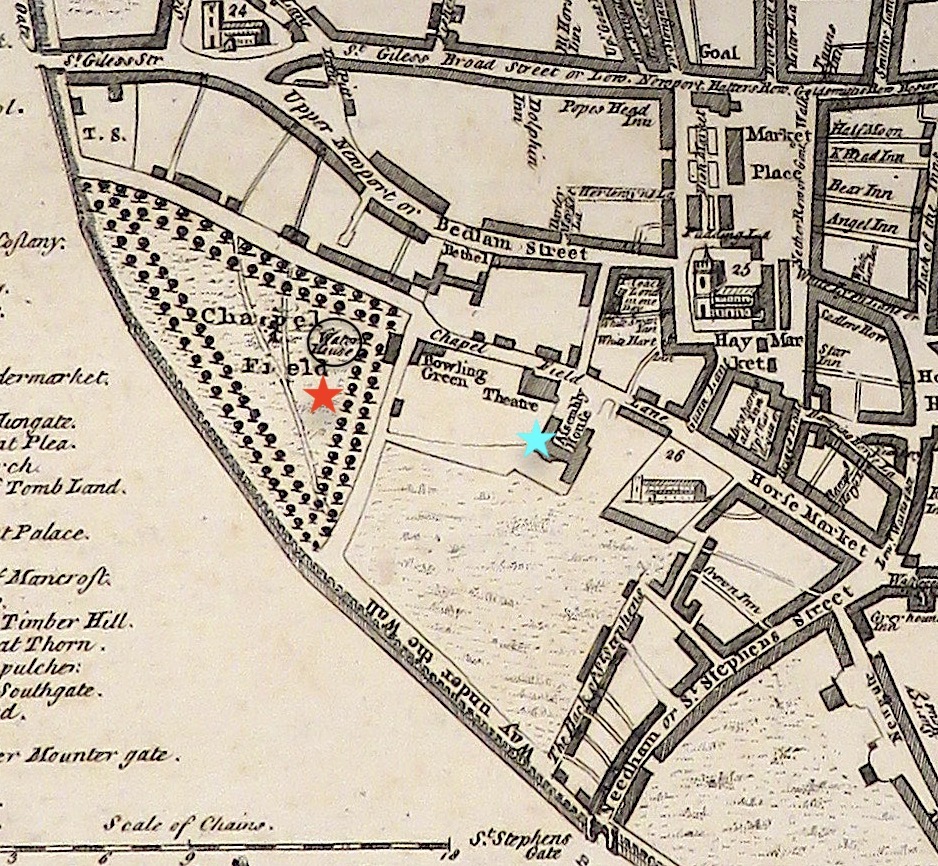
By the time of King’s plan of 1766 the two parts were still largely open ground. Only minor inroads were made by the bowling green, theatre and Assembly House, which provided entertainment for leisured Georgians. On the triangular field we see the double row of elms that lessee Thomas Churchman’s planted for his promenade [2]. This latter portion would survive as present-day Chapelfield Gardens.
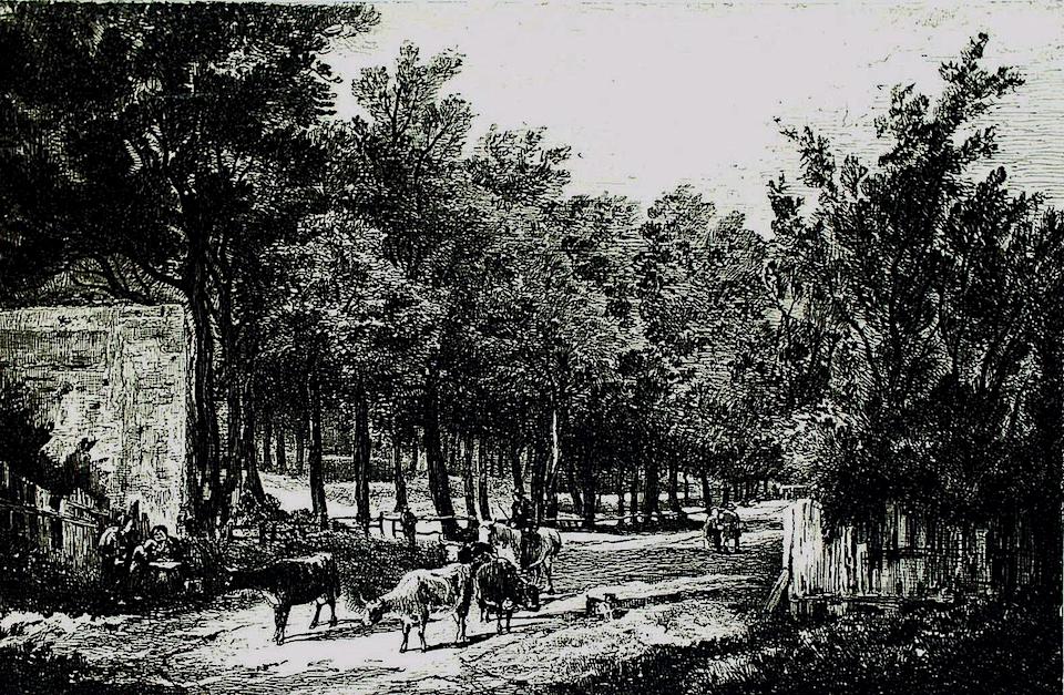
A generation later, Chapel Fields still embodied a sense of bucolic openness as conveyed in the etching by John Crome (1768-1821). The city had always allowed Chapelfield to be used as a public space and in 1656 resisted Lady Hobart’s attempt to prevent citizens passing through [3]. Infilling with shanty housing was the norm in the rest of the city but the only signs of encroachment on rustic Chapelfield are the post-and-rail fencing and the high wall to the left (possibly part of the city wall) .
From the beginning of the eighteenth century the fields were fenced in [3]. In 1867 the council erected iron railings [4], which would be removed in World War Two, purportedly to make guns. This would have been the ‘massive palisade’ supplied by W S Boulton (later of Boulton & Paul) who, ‘produces every kind of railing … also mincing and sausage machines’ [5].
Chapel Fields lies in the crook of the protective arm provided by the city walls, built about 1300. Some 500 years later the gates at its southern and western extremities were demolished to ease the flow of horse-drawn traffic: St Giles’ Gate in 1792 and St Stephen’s Gate a year later. The walls were disappearing too, signifying a loosening of the hold of the medieval past and allowing – if only notionally – the escape of noxious air. In the 1860s, some of the wall around Chapelfield was used as hardcore for the new Prince of Wales Road that connected the markets with the newly arrived railway [6]. Some of the ‘Chapelfield’ wall had been breached by houses built against them.

In 1969, these houses were demolished to make way for the ring road [7].

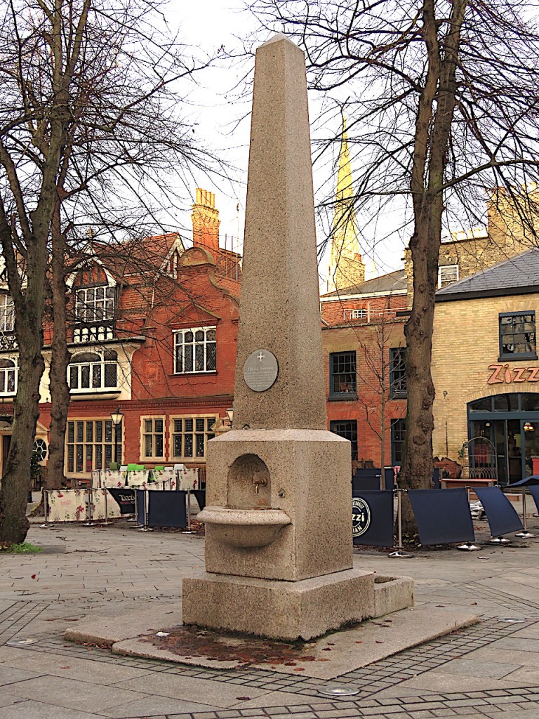
King’s map of 1766 shows a water house within Churchman’s triangular walk, part of the corporation’s scheme to supply water to the city. Water pumped from the river at New Mills (near Westwick Street, upstream of the built-up area) supplied Chapelfield and Tombland. The Tombland works were described in 1698 by Celia Fiennes as ‘a great well house with a wheele to wind up the water … a large pond walled up with brick a mans height … (and) a water house to supply the town by pipes’ [quoted in 8]. This is commemorated by John Henry Gurney’s obelisk and fountain of 1850.
Supply of unfiltered water was therefore restricted to a few parts of the city – and then only to those who would pay for the connection. In 1792, supply was taken over by the Norwich Waterworks Company who built the water tower and reservoir in Chapel Field that appear on Millard and Manning’s map of 1830 [9].
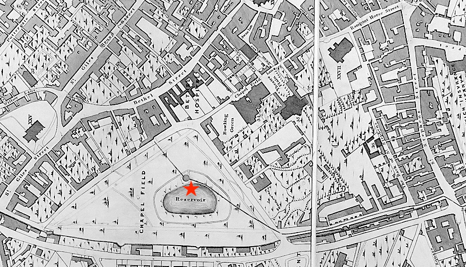
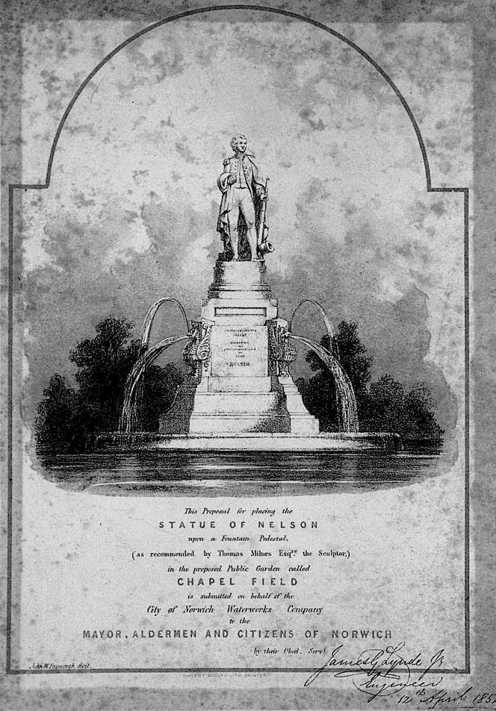
The presence of waterworks in Chapelfield had disturbed the illusion of a bosky retreat where the gentility could associate and by 1840 the park had become ‘the resort of loose and idle boys’ and washerwomen [9]. One idea had been to dignify the site by placing a statue of Nelson on an island in the middle of the reservoir [3]. This never happened and the statue was located, instead, in the cathedral’s Upper Close.
In 1852 the Waterworks Company agreed to hand the land over to the corporation provided they laid it out as a public garden, which they did. By designating Chapelfield Gardens a public park the site was protected from the terraced housing being built just the other side of the city wall.
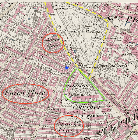
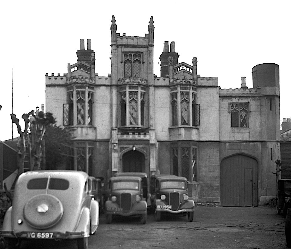
In 1866 the corporation offered the north-west corner of Chapelfield Gardens to the militia for building a drill hall [5]. This castellated Neo-Gothic building, designed by the City Surveyor, Ernest Benest, incorporated part of a tower from the old city wall. The triangular shape of Chapelfield Gardens would be lost when this corner, and the Drill Hall, were flattened beneath the inner ring road of the C20.
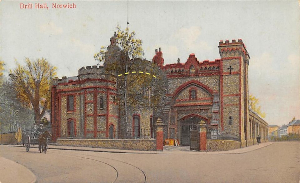
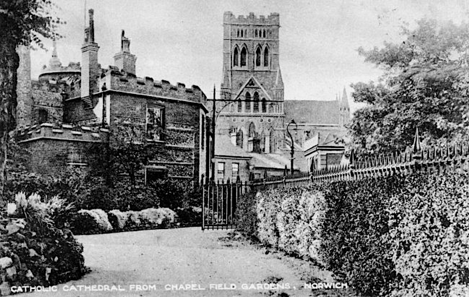
From within this lost north-west corner of Chapelfield Garden we see the back of the Drill Hall and beyond this the Catholic Cathedral, only just completed in 1910. And those must be Mr Boulton’s sturdy iron railings, removed in World War II.
The Drill Hall was demolished in 1963 but the position of the old city-wall tower incorporated into its structure is commemorated by a semi-circle of cobbles on the Grapes Hill roundabout, constructed as part of the 1968-1975 Inner Link Road.

To connect the roundabout with incoming traffic from Earlham Road – which had previously gone straight across to St Giles Street – an awkward fiddler’s elbow (yellow) was created when vehicles were diverted a little way up Unthank Road. Traffic was reconnected with St Giles Street via a spur off the roundabout, creating Cleveland Road (green) in the process. It probably made sense at the time.
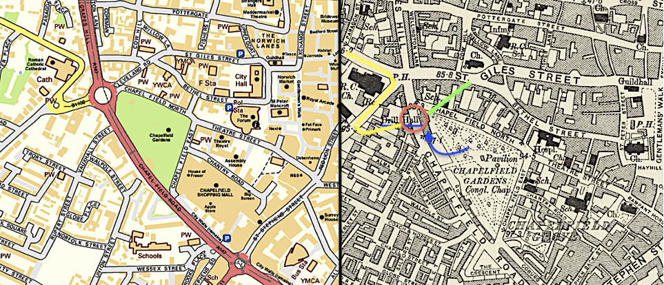
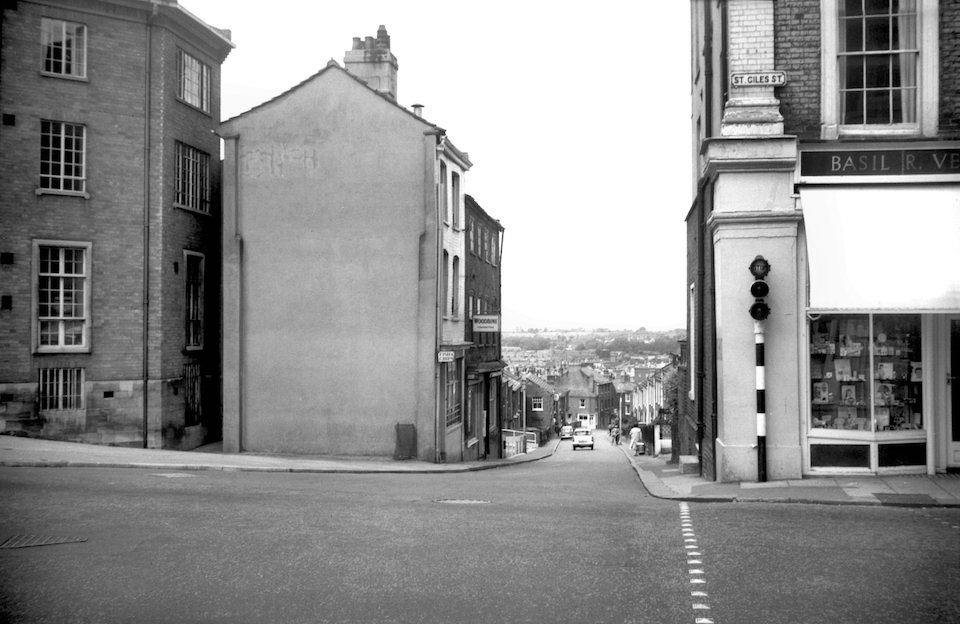
George Plunkett’s invaluable archive of twentieth century photographs shows us the Earlham Road/St Giles Street intersection before the map was redrawn in the late 1960s. Here we look down the narrow street that appears as St Giles Hill on the 1884 OS map and as Grapes Hill in 1908. This was some 60 years before the houses were demolished in readiness for the dual carriageway and the pedestrian flyover built over it. To the far left, at No 1 Earlham Road, is the eponymous Grapes Hotel. It was the only building on the hill to survive the ring road but it was to give way to retirement homes built around 2000. I can recall being able to touch the upper floor of the former Grapes Hotel from the gangway up to the footbridge.
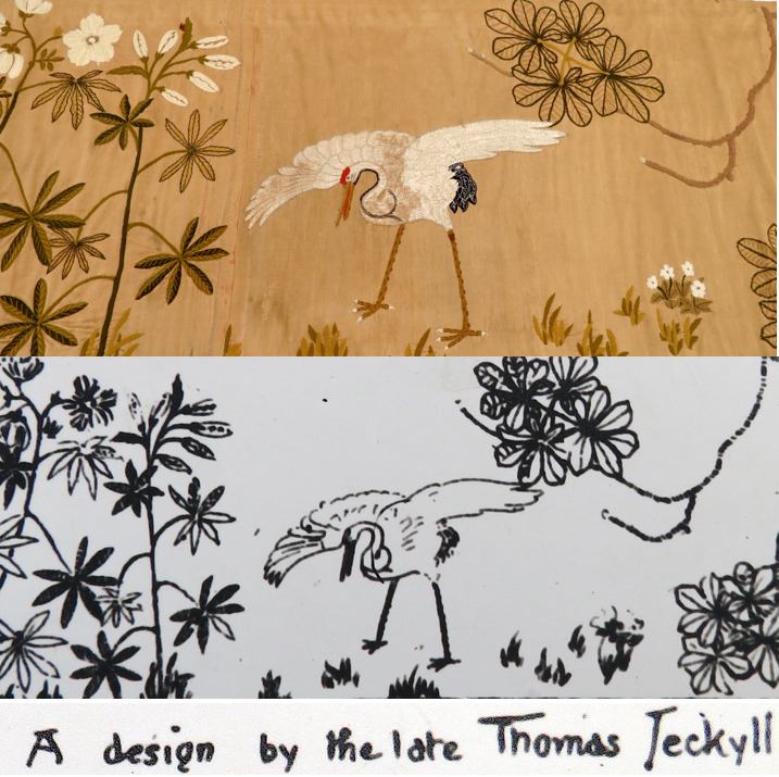
Inside the gardens, one of its most exotic inhabitants was the iron pavilion designed by Thomas Jeckyll. Made by Barnard Bishop and Barnards, and with much of the bas-relief work being forged by Aquila Eke (George Plunkett’s great uncle) it won a gold medal at the Philadelphia exhibition of 1876. Four years later it was bought by the Norwich corporation for £500 and installed in Chapelfield Gardens. I’ve written at length about Aesthetic Jeckyll and his designs for Barnards’ Norfolk Iron Works [e.g., 11], so I won’t run on, but this was the famous ‘Pagoda’, enclosed by railings in the form of uber-fashionable sunflowers – an icon of the Japanese-influenced Aesthetic Movement, here in provincial Norwich. Yet, despite it being a triumph of Norwich craftsmanship, the modernists who wrote the City of Norwich Plan for 1945 judged the Pagoda to be dispensable and so it was demolished in 1949. As Gavin Stamp wrote in Lost Victorian Britain, ‘Victorian, quite simply, was a term of abuse’ during the post-war period.

Designed by Jeckyll, the fabric hangings that once decorated the Pagoda are conserved in the Norwich Castle Study Centre.
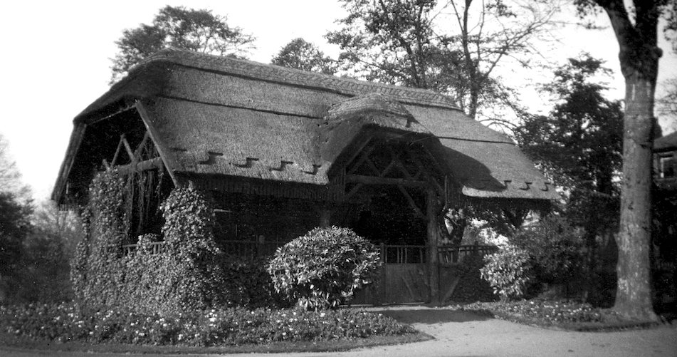
Another occupant of Chapelfield Gardens was a thatched teahouse, known as King Prempeh’s Bungalow, built about the time of the Ashanti campaign in West Africa. Prempeh the First (1870-1931), who had tried to negotiate peace with the British, was captured by an expeditionary force led by Robert (‘Scouting for Boys’) Baden-Powell and sent into exile. In 1902, the Ashanti Kingdom became part of the Gold Coast colony. When Prempeh – once ruler of all he surveyed – was eventually released he found himself Chief Scout of what was now a British protectorate [12].
Surrounding Chapelfield Gardens
From about 1815 the New City arose outside the walls on the south-west side of Chapelfield Road. This signalled the start of the expansion of working-class housing away from the insanitary muddle of the old city. A piece of land once used as a market garden became Crook’s Place and along with Union Place and Julian Place these terraces of small houses were built to accommodate an influx of workers from the countryside [13]. Mostly back-to-back, these modest dwellings with shared privies and water pumps proved to be insanitary and were demolished during rounds of twentieth century slum clearance. A generation later, terraced housing on the Steward and Unthank estates was built to higher standards and continued the city’s westward expansion well beyond the pull of the medieval walls [13].
Built better for polite society, the V-shaped Crescent (1821-1827) survives into the twenty-first century. Nearby, the distinctive Gothic House was demolished as part of the Vauxhall demolition scheme of the 1960s. The Gothic Revival, mostly encountered on Victorian non-conformist chapels around Norwich, hardly touched the city’s domestic housing; the Gothic House is a rare example of this style, here applied as a facade to an older building [14].
The street bounding the gardens to the north, Chapelfield North, is architecturally rich; it hasn’t altered significantly during my 40 years in the city although the ebb and flow of traffic seems to have changed according to various schemes. One bystander that has overseen a more dramatic change in transport fashion is The Garage, now a centre for performing arts.
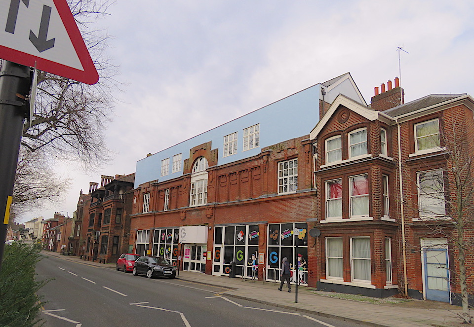
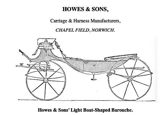
Originally, The Garage was built as the new motor works for Howes & Sons Ltd.
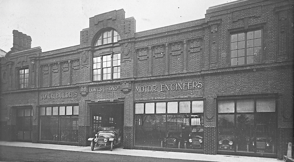
In this photograph Howes were announcing themselves as ‘coachbuilders’ at a time when coachwork had come to mean the body of a motor vehicle. But this was just a breath away from a world when Howes built horse-drawn carriages.
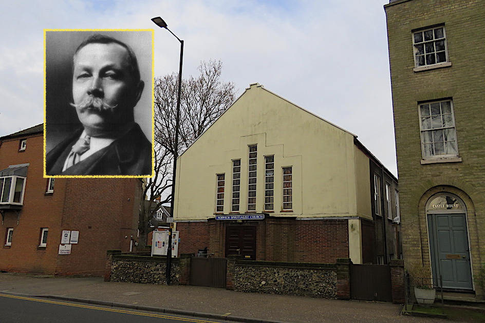
A twentieth century addition to Chapelfield North is the Norwich Spiritualist Church. Built by RG Carter in 1936, this single-storey building was part-funded by proceedings from a post-WWI spiritualist meeting addressed by the faith’s most famous adherent, Sir Arthur Conan Doyle.
The third of the triangle of streets around Chapelfield Gardens is Chapelfield East, which divides the gardens from the larger block that once housed Caley’s chocolate factory (later, Rowntree Mackintosh then Nestlé). Demolished to make way for the Chapelfield Shopping Centre (2005) this complex was – with a nod to its ecclesiastical heritage – recently renamed as Chantry Place.
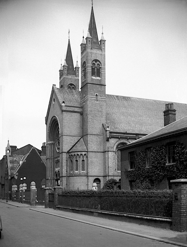
On this street Chapelfield East Congregational Church once stood, a prominent landmark with twin 80-foot towers. As George Plunkett noted [15], a stranger could have been excused for thinking it was this chapel that gave name to the neighbouring public garden. Of course, it was far too young, arising in 1859 to be demolished in 1972.
© 2022 Reggie Unthank
Sources
- Francis Blomefield (1806). ‘History of the County of Norfolk’ 4, part 2 Chapter 42 City of Norwich. Online at: https://www.british-history.ac.uk/topographical-hist-norfolk/vol4/pp145-184#h2-0003
- https://colonelunthanksnorwich.com/2021/11/16/georgian-norwich/
- Frank Meeres (2011). The Story of Norwich. Pub: Phillimore & Co. Ltd.
- https://historicengland.org.uk/listing/the-list/list-entry/1001645
- A.D. Bayne (1869). A Comprehensive History of Norwich https://www.gutenberg.org/files/44568/44568-h/44568-h.htm
- Nikolaus Pevsner and Bill Wilson (1997). The Buildings of England. Norfolk 1: Norwich and North-East. Pub: Yale University Press.
- http://www.georgeplunkett.co.uk/Norwich/cat.htm#Chafe
- Margaret Pelling (2004). Health and Sanitation to 1750. In, Norwich since 1550. Eds: Carol Rawcliffe and Richard Wilson. Pub: Hambledon and London.
- https://historicengland.org.uk/listing/the-list/list-entry/1001645
- https://www.norwich.gov.uk/site/custom_scripts/citywalls/21/report.php
- https://colonelunthanksnorwich.com/2016/01/06/jeckyll-and-the-sunflower-motif/
- https://en.wikipedia.org/wiki/Anglo-Ashanti_wars
- Rosemary O’Donoghue (2014). ‘Norwich, an Expanding City: 1801-1900.’ Pub: Larks Press.
- Noël Spencer (1978). Norwich Drawings. Pub: Noël Spencer and Martlet Studio.
- http://www.georgeplunkett.co.uk/Norwich/cat.htm#Chafr
Thanks: I am grateful to Clare Everitt of Picture Norfolk and to the George Plunkett collection for permission to use photographs.

Thanks so much for this. I live close to Chapel Fields and the wealth of interesting information you have compiled here will really enhance my enjoyment when walking in this area.
LikeLike
Thank you Philip. Chapelfield is such a rich area to delve and there’s a lot more that could be written. Next time, perhaps Caley’s chocolate factory?
LikeLike
Great piece about Chapelfield and the surrounding roads/buildings. Do you know why the Congregational Church was demolished? It looks a splendid building.
LikeLike
According to George Plunkett: “Chapel-in-the-Field Congregational Church was closed in the 1960s because depopulation of the surrounding area led to a diminished attendance and because increased traffic in adjacent roads created difficulties of access. The last service was held on 30th December 1966, after which its members united with the congregation of another Congregational church in Jessopp Rd.” It does look to have been a fine building.
LikeLike
Thanks Reggie 🙂
LikeLike
Thank you! I only just realised I could send my appreciation this way. Especially love the pagoda. Happy 2022. Gillian
LikeLike
Wasn’t the pagoda something special? I fume at the decision of the postwar planners who cut a swath through old Norwich, blind to any magic that stood in its way. HNY to you, Gillian.
LikeLike
The development and uses of Chapelfield Gardens over the centuries provide a interesting sub-plot in the history of Norwich. I had forgotten that what I knew as the Grapes pub was actually grandly designated the Grapes Hotel!
While Howes garage was in Chapelfield North, on the other side of Chapelfield was Boshier’s garage, now subsumed into the odd blue building, Norvic House. Next to the Grapes Hotel on Earlham Road was Duff Morgan and Vermont’s garage, which had originally stood behind the old St Stephens Street about where Shoezone is, so by the 1970’s Chapelfield rivaled Prince of Wales Road as the centre of Norwich’s motor trade.
Thank you for this interesting post
LikeLike
Hello Don, Yes, that odd blue building … I actually bought a Citroen from Duff (perhaps not the ideal name for car sales) Morgan. The car was great. With the touch of a button the car rose up and transported me over flood waters.
LikeLike
Thank you, Clive. I’ve seen snippets of information about Chapel Field over the years but you’ve brought it together magnificently and revealed plenty that was new to me. Apparently, a direct hit on one of Chapel Field Garden’s air raid shelters killed three people in April 1942.
LikeLike
Hello John, I hadn’t heard about the deaths in Chapelfield Gardens. I believe that all of the city’s parks had been prepared for war. Centuries earlier Chapelfields was a plague pit.
LikeLike
Once again a very interesting post. It is hard for us Norwich oldies to remember what the top of Grapes Hill used to be like before the roundabouts and pedestrian bridge. Congratulations on your big mention in Christopher Howse’s Sacred Mysteries column in the Daily Telegraph of Saturday 8th January.
LikeLike
Hello Stephen, I came to Norwich in the 1980s and even some of the things I saw then are now historical. I was surprised and delighted to get Christopher Howse’s coverage.
LikeLike
Thank you Reggie, Chapelfield Gardens was a very important part of my childhood in the 1950s. My mother took us to play there every day after her daily shopping and we went there to play on our own when we were old enough. My sister and I attended Chapelfield Congregational Church in the early sixties, only, to be honest, to allow us to go to youth club on Saturday evenings and we always ran past the Spiritualist Church to avoid any lingering ghosts. I remember the top of Grapes Hill had a very good fish and chip shop and the Milk Marketing Board close by on Unthank Road did a very nice milk shake for a shilling. For a real though rare treat you could go to a side door at Caleys and buy a bag of chocolate mis shapes for sixpence.
LikeLike
What wonderful memories, Jane; they help bring my static images alive. I didn’t realise the Milk Marketing Board sold milk shakes from their offices at the bottom of Unthank Road.
LikeLike
Amazing to read all this Norwich with old photos
I used to cycle, up and down Unthank Rd, to the Maddermarket Theatre. I performed in several , with Sir Nugent producing.
I was Margaret, in “ Much Ado about Nothing “ 1950?
And, cycling from the corner of Unthank / Colman Rd to the ZNorfolk and Norwich Hospital “ X Ray “ for 2 years till I qualified as a Radiographer 1952
LikeLike
Dear Minda, How wonderful to hear those memories of cycling down the celestial Unthank Road to rehearse with Monck at the Maddermarket. Thank you.
LikeLike
Excellent research Reggie, I would love to use this sometime on my group on Facebook “Norwich back in time” full credit given of course.
LikeLike
Go ahead Gordon. I don’t use Facebook but I’ve been told I’m missing out on the Norwich history there.
LikeLike
thank you my friend appreciate that very much
LikeLike
Hello Reggie.Just something that may be interesting on Norwich STREET NAMES. As you know I work as a security officer at the now closed COLMAN’S FACTORY. In reference to Mr James Stuart (Married to Laura Colman) who lived at Carrow Abbey I notice that two street names are named ‘Alan Street’ (Named after the late Alan Colman) and ‘Stuart Street’ (Named after James Stuart himself).Next lane is WINKLES ROW. Last year I purchased a book on e bay ‘Reminiscences’ by James Stuart. When I received the book inside were letters, photographs and a note within saying the book was given by Mr Stuart to a Mr WINKLES who knew and helped Mr Stuart as the book was given as a token of appreciation for work given. (See attachments).Could the Norwich Street ‘WINKLES LANE’ be the same gentleman that Mr Stuart knew and thus named this little lane after him ? Perhaps you know the reason behind the naming of ‘Winkles Lane’ as it seems a very strange coincidence the 3 streets are within the Carrow area ? Yours KindlyJulian A HanwellCarrow Security.
LikeLike
Hello Julian, I knew about Alan and Stuart Streets being named after members of the Colman family but hadn’t really clocked Winkles Row. Since this was Colman’s territory, close to the factory, it sounds reasonable that it was also named by the Colman family. I’d be interested to hear more about Mr Winkles. Thank you for the fascinating comment, Reggie
LikeLike
Hi, Reggie! Chapelfield Congregational Church was a fine building inside as well as out. When the Presbyterians and Congregationalists merged it was, alas, surplus to requirements. I can remember going to rock concerts there in the early ’70s. Our band featured- once. We were terrible! By the way Have you any wisdom to impart on the Grapes Hotel at the top of Grapes Hill? I gather it was demolished about fifteen years ago to make way for the Royal Arch Court. A block of flats from the ’50s, innocuous enough, replacing the actual hotel which was blitzed. I seem to recall it having a retail outlet for Barwell and Sons on the ground floor- I picked up an order for a couple of pins of Abbot there for my 21st in 1975. I seem to be about the only person to remember this. A false memory, alcohol induced? The George Plunkett taken from the bottom of Unthank Road does seem to show a shop, next to an archway for deliveries. I just wondered if you had any recollection of any of this as it is right on your patch……….! MGR.
LikeLike
Hi Mike, No false memory, I remember the the 50s block of flats at the top of Grapes Hill. It was possible to touch the building from the pedestrian flyover. I showed a Plunkett photo of it in a post on Chapelfield, earlier this year (you’ve probably seen this).There’s also a good view of it on Picture Norfolk/Grapes Hill, but no Grapes Hotel. All best, Reggie
LikeLike